Technical Introduction
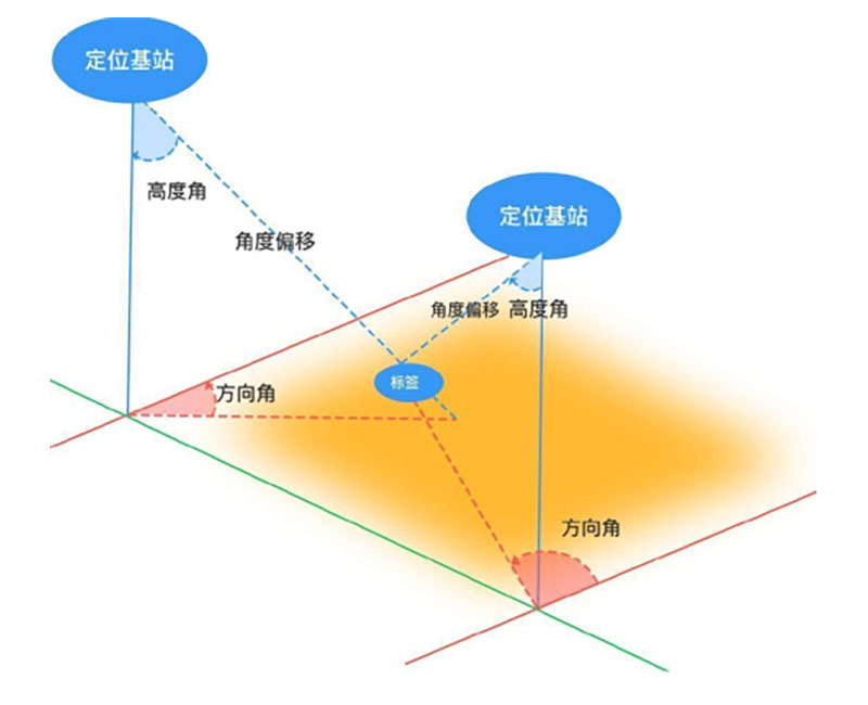
Bluetooth AOA positioning is a centimeter level indoor positioning technology that uses advanced Angle of Arrival (AOA) algorithms and standard Bluetooth Low Power (BLE) technology based on the original RSSI (Signal Strength) for Bluetooth positioning. Even in harsh environments, it can provide customers with real-time and high-precision positioning. The basic principle is that the tag transmits wireless signals to the positioning base station. The antenna array in the positioning base station receives wireless signals from the same signal source at different time points. By analyzing the time difference of arrival, the azimuth and elevation angles of the tag to the positioning base station are calculated, and then combined with signal strength estimation, the target is accurately located in a two-dimensional plane (two or more positioning base stations can perform spatial positioning on the same target).

Location
The basic positioning principles of Bluetooth AOA include single base station positioning, two-dimensional positioning, and multi base station positioning.
Single base station positioning: If the height change of the located terminal is small, a fixed height single base station can be used.

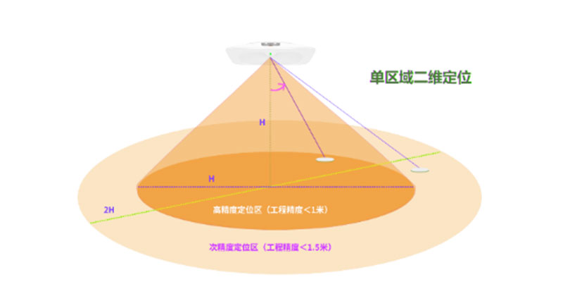
2D positioning: By using AOA angle estimation, a ray starting from the base station can be obtained, which intersects with the height plane of the positioning terminal to obtain the plane coordinates. The positioning coverage of a single base station is a conical area centered around the base station. The farther it is from the base station, the greater the change in plane coordinates caused by the same angle error, and the greater the position error. The closer it is to the base station, the better the positioning accuracy. The coverage range of high-precision positioning areas can be improved by appropriately increasing the height difference H between the terminal and the base station.

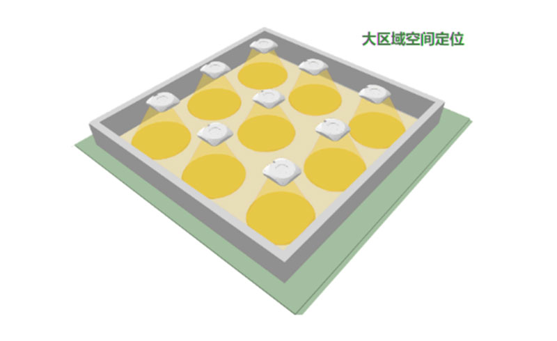
Multi base station positioning: Based on the two-dimensional positioning of a single base station, large-scale networking of various positioning base stations is carried out, and joint calculation of multi base station heading angles is carried out to achieve full coverage of high-precision positioning with a larger scale.
Application Scenario
1、 Enterprise service field
1. Intelligent manufacturing
For many intelligent manufacturing fields such as automotive assembly and manufacturing, electronic manufacturing, etc., Bluetooth AOA high-precision positioning technology is used to achieve personnel management, material positioning and tracking, production process traceability, adaptive tool search, and error prevention.
2. Warehouse logistics
Combining Bluetooth high-precision positioning technology with RFID technology, barcodes, and QR codes to improve warehouse order and material circulation efficiency. This includes personnel management, vehicle equipment scheduling, cargo dynamic management, vehicle management, and AGV collaborative automation.
3. Electric energy
Based on real-time collection of positioning data, intelligent personnel position management, attendance management, roll call statistics, and scheduling management have been achieved. Set access permissions for different staff members to enter and exit the area, and combine them with electronic fences to avoid safety accidents caused by personnel mistakenly entering the restricted area.
4. Smart Supermarket
Utilize location information to improve consumer shopping experience, promote products, and optimize operations using location data.
2、 Government and public service sector
1. Transportation Hub
Airports, parking lots, transportation hubs, and other places provide users with navigation and route planning, scientifically guiding the diversion of vehicles and crowds, ensuring operational safety and improving operational efficiency.
2. Medical care
Management of mobile nursing rounds for medical staff, compliance management of hand hygiene for medical staff, efficient tracking and deployment of life-saving materials, tracking and timely care for special populations, identification and theft prevention of newborn infants and young children.
3. Public Prosecution and Legal Department
Real time control of personnel's real-time location, counting of personnel, alarm for preventing the dismantling of prisoners' wristbands, electronic fence, crowd analysis, action trajectory tracking, playback, camera linkage alarm, etc., to reduce the risk of regulatory law enforcement and prevent the occurrence of accidents.
4. Museum Exhibition
In exhibition centers, museums, and other places, intelligent navigation and guidance services can be implemented, which can guide visitors to the desired booth in real-time. In addition, accurate statistics can be made on the location data of visitors, viewing the viewing trajectory and dwell time of exhibition customers and staff in the exhibition hall, achieving accurate analysis of exhibition performance. Let exhibitors understand the products that exhibitors are interested in, and provide clear direction for improving the quality of the exhibition in the future.
5. Mines, tunnels, underground pipe galleries
Implement personnel management, risk control, emergency rescue and other functions to ensure the safety, quality, and progress of workers' construction inspections.